Log in
All resources
Create a design
4,963 Free Images of Map Pin
bibliothèque nationale de france
john rocque
map of bruges by marcus gheeraerts (i)
marcus gheeraerts the elder
travel
drawings in the groeningemuseum
etching print
groeningemuseum
destination
turgot map of paris, kyoto university library – derivative files
maps by girolamo porro
1596 maps of africa
map of the circle of franconia by sanson
1680s maps of bavaria
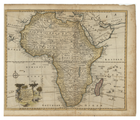
1529 maps of africa
1529 maps of iran
1529 maps of iran
1529 maps
maps of amsterdam in the rijksmuseum amsterdam
map of amsterdam, 1544
carta hydrographica y chorographica de las yslas filipinas
baroque painting
turgot map of paris, kyoto university library – derivative files
enclos saint-lazare
maps by petrus schenk
1750s maps of saxony
cornelius aurelius world map
ptolemaic taprobana
travel
maps
map of rome by giovanni battista falda (1676)
maps in the rijksmuseum amsterdam
map of maastricht by willem and johannes blaeu (1649)
jezuïetenwal (maastricht)
historical map collection
maps by emanuel bowen
john rocque's 1746 map of london
details of old maps of london
woman
girl
edward wright (mathematician)
maps by jodocus hondius
leicester square
leicester house
18th-century maps of ireland
old maps of dublin
john rocque's 1746 map of london
details of old maps of london
map of ghent by folkema, harrewijn, 1785
collections of ghent university library
stedenboeken van de wereld by johannes janssonius 1657
map of ghent by jan blaeu
map of ghent by lucas de heere
collections of archief gent
destination
travel
1520s maps of the world
propaganda map
john rocque 1746 london map (a1-h3)
st george's fields, southwark
koninklijk oudheidkundig genootschap, amsterdam
map of amsterdam, 1544
eran laor cartographic collection
afbeeldinge der stad jerusalem
map of bruges by marcus gheeraerts (i)
drawings in the groeningemuseum
1747 persia map by emanuel bowen
1740s maps of georgia
map of paris by braun & hogenberg - derivative files
pont aux meuniers
maps of paris from bibliothèque nationale de france
dheulland map of paris
arnold van langren map of southwest africa
renaissance
map of paris by braun & hogenberg - derivative files
le marais
historical images of place du carrousel
rue saint-nicaise (paris)
maps of paris from bibliothèque nationale de france
dheulland map of paris
key sheet of the turgot map of paris
maps of paris from paris musées
1747 persia map by emanuel bowen
1740s maps of georgia
brazilian paintings in the museu antônio parreiras
textile and oil painting on canvas
john rocque's 1746 map of london
maps of woolwich
steinfels collection
engravings of bern
demolished churches in de barbari map
sant'angelo (venice)
demolished churches in de barbari map
sant'agostin (venice)
brazilian paintings in the museu antônio parreiras
textile and oil painting on canvas
maritime history of india
sailing ships of india
curt teich postcard archives
map postcards
curt teich postcard archives
afton, oklahoma
postcards of oklahoma county, oklahoma
curt teich postcard archives
map of maastricht by willem and johannes blaeu (1649)
atlas beudeker
map of the circle of westfalia by sanson
louis cordier
1698 map of evesché de meaux
robert cordier (engraver)
map of paris by truschet and hoyau - derivatives files
église saint-sulpice on old maps
coats of arms of sweden and poland (personal union)
details of sigismund's map of moscow
turgot map of paris, kyoto university library – derivative files
chapelle saint-éloi (paris)
reconstructions of old maps
german renaissance
reconstructions of old maps
german renaissance
jodocus hondius ii, nova totius terrarum orbis geographica ac hydrographica tabula, 1636
eran laor cartographic collection
hendrik van langren map of south asia
1590s maps of the levant
maps in the rijksmuseum amsterdam
johannes blaeu - map of antwerp
1890s maps of ethiopia
fra mauro map details
prints in the stadsarchief amsterdam
map of amsterdam, 1544
david rumsey historical map collection
maps of rügen by eilhard lubinus
atlas des anciens plans de paris by imprimerie nationale, 1880 from bhvp
dheulland map of paris
curt teich postcard archives
map postcards
atlas des anciens plans de paris by imprimerie nationale, 1880 from bhvp
dheulland map of paris
map of the circle of upper saxony by sanson
1700s maps of saxony
john rocque's 1748 map of london and adjacent country
remigius parr
map of modern syria by philippe de la rué
bibliothèque nationale de france
john rocque's 1748 map of london and adjacent country
remigius parr
map of modern syria by philippe de la rué
bibliothèque nationale de france
map of europe by nicolas and guillaume sanson (1669)
1680s maps of europe
map of modern syria by philippe de la rué
bibliothèque nationale de france
1650s maps of the world
age of discovery
vegetables
plants
map of bruges by marcus gheeraerts (i)
drawings in the groeningemuseum
turgot map of paris, kyoto university library – derivative files
église saint-sulpice on old maps
turgot map of paris, kyoto university library – derivative files
foire saint-laurent
truscott map of st-petersburg 1753
engraved maps of saint petersburg
map of bruges by marcus gheeraerts (i)
drawings in the groeningemuseum
map of bruges by marcus gheeraerts (i)
drawings in the groeningemuseum
map of bruges by marcus gheeraerts (i)
drawings in the groeningemuseum
map of bruges by marcus gheeraerts (i)
drawings in the groeningemuseum
map of bruges by marcus gheeraerts (i)
drawings in the groeningemuseum
18th-century maps of crimea
1780s maps of ukraine
maps of paris from bibliothèque nationale de france
ludovic baschet
map of bruges by marcus gheeraerts (i)
drawings in the groeningemuseum
turgot map of paris, kyoto university library – derivative files
plans of the musée rodin
travel
maps
travel
maps
travel
maps
turgot map of paris – derivative files
maison du temple (paris)
travel
maps
destination
travel
map of bruges by marcus gheeraerts (i)
old maps of sluis
history of greenwich (district of london)
john rocque 1746 london map (a1-h3)
the annals of the voyages of the brothers zeno (1898)
fra mauro map derivative works
maps of the ottoman empire by mercator-hondius
eran laor cartographic collection
landscape
nature
john rocque's 1746 map of london
northumberland house
17th-century double hemisphere world maps
mercator 1587 world map
1730s maps of the americas
1730s maps
2401 - 2500 of 4,963
Next page
/ 50


![[Reproduction of the terrestrial globe (orbis imago) by Jean Stabius, 1515] (Facsimile reproduction)](https://cdn.creazilla.com/illustrations/10000450806/reproduction-of-the-terrestrial-globe-orbis-imago-by-jean-stabius-1515-facsimile-reproduction-sm.jpg)
![[Reproduction of the terrestrial globe (orbis imago) by Jean Stabius, 1515] (Facsimile reproduction)](https://cdn.creazilla.com/illustrations/10000781714/reproduction-of-the-terrestrial-globe-orbis-imago-by-jean-stabius-1515-facsimile-reproduction-sm.webp)